Today
Today  Tomorrow
 Tara Hill Walking Trail
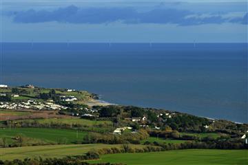
Tara Hill (252 metres) is a heather-sloped rocky outcrop that has stunning panoramic views up and down the Wexford and Wicklow coastline. There are 2 walking trails, starting from two different trailheads which give you different flavours of Tara Hill and its surroundings.
The Red Trail, Slí an tSuaimhnais, begins from Tara Hill cemetery just beyond the village itself. There is ample car-parking space here. The trail brings you along atmospheric laneways which now and again open out to reveal the wonderful views of the coast. Look out for a 1798 graveyard along the way. On the final sections of this walk, you will notice the Stations of the Cross attached to the trees. Locals once came to pray along here in remembrance of times past.
The more demanding Blue Trail, Slí na n-Óg, begins at the Ballinacarrig parking place (known locally as the Crab Tree). This trail encompasses not just the higher slopes of Tara Hill itself, but its fascinating historical past. Along the way, you will encounter the remains of a famine village, Soldier’s Hollow, Table Rock and on the summit, the cairn. This cairn has the crow’s-foot mark showing it was part of a military survey, using its height to provide possible defence in times of invasion. From this position can be seen Mount Snowdon in Wales, Croghan Kinsella in Co. Wicklow and Oulart Hill further south in Co. Wexford.
On both walks, flora and fauna are in abundance, and the keen-eyed walker will sometimes spot the sparrowhawk and kestrel.
If you want to explore more Wexford walking trails, don’t miss our blog Best Walking Trails in County Wexford.